
Joaquin Seen From Space
| published October 2, 2015 |
By Thursday Review staff
Hurricane Joaquin is bearing down on the East Coast of the United States, bringing with it high winds, a heavy storm surge, and as much as ten inches of rain in some areas. In the Atlantic Ocean’s open waters, the storm gains speed and power, with outer spiral arms which stretch more than 1000 miles in diameter.
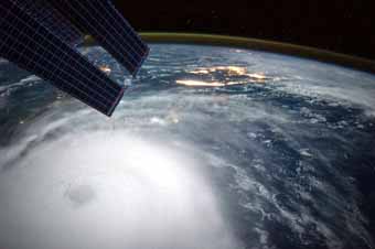
Seen from space, Joaquin’s intensity and sprawling size makes for an easy target for the lens of NASA astronaut Scott Kelly, now a little more than halfway through his mission of completing one year in orbit aboard the International Space Station.
Kelly captured this photo early in the morning of October 2 as Joaquin—officially a Category 4 monster—moved north-northeast through the southern Bahamas and toward the U.S. coast. Though it would appear Joaquin is threatening Florida, an eastbound high pressure system will meet the outer bands of the hurricane before then, pushing the storm northward, whereupon meteorologists expect it to then target the Outer Banks or Washington, D.C. before dumping heavy rains across much of the upper East Coast.
Other forecasts show the storm possibly moving slowly along the coast, but remaining largely at sea—and though in this scenario it will still bring some rain, a large swath of the east coast may avert what could have been severe flooding.
Related Thursday Review articles:
Biomedical Experiments in Space; Keith H. Roberts; Thursday Review; August 6, 2015.
Space Station: A Close Call With Space Junk; Thursday Review staff; Thursday Review; July 17, 2015.